Find Professionals
Consult.       Engage.      Collaborate.
Home             List All Professionals             List By Areas of Expertise
Nonguierma
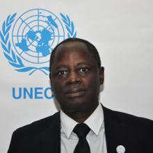
Andre Nonguierma
United Nations Economic Commission for Africa, Addis Ababa
Chief, GIMS, ACS- Geospatial Information Management System
Andre Nonguierma holds an Engineer Degree in Environment from the Polytechnic Institute of the University of Ouagadougou in Burkina Faso. He also holds a MSc. in Applied Remote Sensing and Geographic Information Management from the University of Agronomic Sciences in Gembloux, Belgium. He is currently the Chief of the Geospatial information Management Section. In this capacity, he oversees the ECA work on advancing holistic geospatial information management policies and strategies and providing assistance to Member States and regional entities in the development and implementation of spatial data infrastructures, space science and geospatial information technology. Andre Nonguierma bring more than 25 years of professional experience in the field of space science, earth observation and geospatial science and technology. His professional journey is highly focused on leveraging geospatial data, information, and analytics to support strategic decision-making and evidence-based policy analysis across a range of application from the public sector to academia and the private sector. Andre Nonguierma has published several scientific papers and continues to conduct research activities on SDI, GIS, spatial analysis, Remote Sensing applications, space technologies and Earth Observation solutions to various socio-economic sectors.
Areas of Expertise
Agricultural Environment And Natural Resources, Agriculture, Forestry And Fishing, Cartography, Data Management, Earth Sciences, Environment, Environmental Science, Geography, Geospatial Analysis, Gis, Hydrology And Oceanography, Information Management Systems And Technology, Natural Resources And The Environment, Natural Resources Management, Rural Development, Science And Technology, Statistics, Sustainable Development

Education:

Bachelor's degree
Environmental Science
Université de Ouagadougou / University of Ouagadougou
Maîtrise des Sciences et Techniques du Développement Rural
Master's Degree
Environmental Science
Université de Ouagadougou / University of Ouagadougou
Diplôme Ingénieur Polytechnique du Développement Rural
Master's Degree
Remote Sensing
Faculté des Sciences de Gembloux
Remote Sensing and Planning

Language:

English
French
Moore

Publication:

Guidelines for the Implementation of National Spatial Data Infrastructure in African Countries

Publications Section

Economic Commission for Africa

2020
Geospatial information for sustainable development in Africa: African Action Plan on Global Geospatial Information Management - 2016-2030

Economic Commission for Africa

Publications Section

2017
Volunteer Geographic Information (VGI) in Africa: Guidelines in Citizens participation in mapping

Economic Commission for Africa

2017
Spatial Data Infrastructures in Africa: A Gap Analysis

Journal of Environmental Informatics

2017
One Continent, One Representation : Progress on AFREF, a common geodetic reference frame for Africa
2016
The African Geodetic Reference Frame: Development Between 2000 and 2015

GIM International

2016
Enabling Discovery of African Geospatial Resources

Journal of Earth Observation and Geomatics, Vo4, No1S, 2015

2015
Africa Science, Technology and Innovation Review 2013

Economic Commission for Africa

2013
Lutte contre la sécheresse au Sahel : résultats, acquis et perspectives

Sécheresse |John Libbey Eurotext

2009
Suivi opérationnel par télédétection des plans d’eau en milieux arides à l’aide des données de l’instrument VEGETATION

Sécheresse |John Libbey Eurotext

2009
Détermination du degré d’aridité bioclimatique de sept localités du département de Tillabéri

Sécheresse |John Libbey Eurotext

2005
Evaluation et suivi des plans d'eau de surface par télédétection

Sécheresse |John Libbey Eurotext

2001
Applications opérationnelles de la télédétection pour les études hydrologiques au Sahel

Sécheresse |John Libbey Eurotext

1994
Methods to characterize landfacets using remote sensing data and GIS in Burkina Faso

EARSel

1993
Utilisation de l'imagerie satellitaire pour l'étude des bas-fonds au Sahel

Sécheresse |John Libbey Eurotext

1991
Yes